Vr Mapping |
ON-LINE REFERENCE DOCUMENTATION CARDINAL SYSTEMS, LLC |
Classify Points (ClaPoi) / Bare Earth (BarEar)
Type: Batch Application
Classifies VrPoints (LiDAR) from aerial sources into bare earth (ground) and non-ground classifications.
Detailed Description
The identification of LiDAR points that make up the ground surface has many practical application in the processing of this type of data. Bare Earth generation is normally the first step when generating a Digital Terrain Model (DTM) surface and then contours from LiDAR data. After the Bare Earth points have been identified, the Keypoint (KeyPoi) batch application is run on the Bare Earth points to identify the most efficient points to use for the DTM surface.
The process of classifying LiDAR points based on this criteria is also referred to as Bare Earth generation. The Classify Points / Bare Earth batch application may be started from the ClaPoi key-in or the BarEar key-in. The names Classify Points and Bare Earth along with the key-ins are interchangeable.
Configuration Considerations
Since the classification of LiDAR points is a memory intensive application it is recommended that Classify Points be run from VrOne only without the use of 3D VrThree. Although possible, it is not recommended running Classify Points from VrTwo. The use of the 64-bit version of VrOne if using Windows 7 64-bit is also recommended for this application since this configuration offers a significant increase in available memory to the software.
History and Status
Classify Points was first introduced in VrOne version 05.05.22. This version is considered a beta version and the results should be checked carefully. It is suggested that the target VrOne files be backed up before using Classify Points.
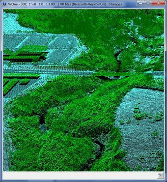
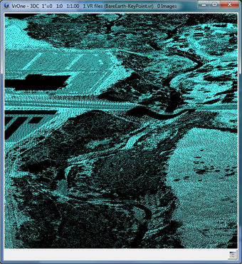
Two examples showing all classifications (left) and bare earth classified points (right)
Available Key-ins
Key-in |
Description |
Range |
RUN |
Run Classify Points |
|
Starting Classify Points with a key-in of "ClaPoi RUN" or "BarEar RUN"will run the batch application without prompting for parameters. The previous parameters will be used. It is possible to set the initial parameters by starting Classify Points (ClaPoi) with no arguments, entering parameters then pressing Cancel. The parameters will be saved as the previous parameters.
Parameters for Classify Points / Bare Earth
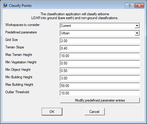
Classify Points / Bare Earth parameters dialog
Workspace to Consider
Defines the workspaces to consider when running Classify Points. Options are Current workspace or All open workspaces. When running, you can process the current workspace or all loaded workspaces. If similar settings are expected to be used for all open workspaces, processing them in a single session by specifying all open workspaces is optimal. For testing or for initial parameter setup, using a single (current) workspace may be desirable. (default: current)
Predefined parameters
Allows the eight parameters (Grid Size to Outlier Threshold) to be saved and recalled by a user defined selection. For example, predefined parameters for terrain types such as urban, suburban, forested, and hilly can be stored. A terrain type's parameters may be recalled by selecting it from this combo box. The "Modify predefined parameter entries" button allows the addition and deletion of predefined parameters.
Grid Size
Specifies, in ground units, the resolution of the grid (or cell) size used by the classification algorithm. Smaller cell size will improve results on varied terrain but will take longer to process. A larger grid size will process much quicker, use less memory, but may have more false vegetation (or non-bare earth) detections. (default: 2 meters / 6 feet)
Terrain Slope
Average or representative slope in the area (for example, sloping land in the direction of water). For flatter areas, a value of 0.15 might be used. For a hilly area, a value of 0.35 might be used. (default: 0.2)
Max Terrain Height
Assumed maximum elevation of the bare earth surface or ground, in ground units. Any point above this height is classified as non-bare earth. (default: 10–15 meters / 32-50 feet)
Min Vegetation Height
The lowest vegetation, of any significance, that would be expected to find in the area in ground units. (default: 0.5-1 meter / 1-3 feet)
Min Object Height
Minimum height, in ground units, above the ground layer that points must be to be classified as non-bare earth. (default: 1 meter / 3 feet)
Min Building Height
Lowest terrain height, in ground units, that is could be found in the local buildings in the area being classified. (default: 3 meters / 10 feet)
Max Building Height
Maximum height, in ground units, that can be covered by a building. For example, if the height covered by a mass of points exceeds this value, then the area is probably a plateau or a change in
elevation such as a steppe, shoreline or hilltop. In a city setting, a value of 150 meters or 500 feet would help find the larger buildings. In a country setting where the buildings are smaller, a value of 50 meters (150 feet) or less could be used. (default: 50-150 meters / 150-500 feet)
Outlier Threshold
Specifies the threshold in ground units outside of which data points are disregarded in the classification calculations so as to maintain and improve the accuracy of the classification results. (default: 10 meters / 30 feet)
Modify predefined parameter entries
Allows the creation of new predefined parameters or the deletion of existing predefined parameters. Both actions may be done simultaneously, the only constraint being that adding and deleting the same entry simultaneously will yield in no action taken.
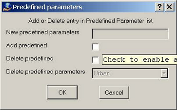
Predefined parameters dialog
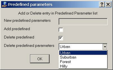
Predefined parameters dialog deleting parameter definition
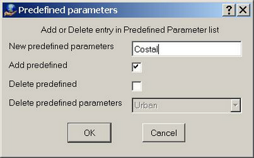
Predefined parameters dialog adding parameter definition
Once a new entry is entered and/or an existing one selected for deletion and the OK button is clicked, the Predefined parameters field of the Classify Points prompt box will be populated with the new entry and corresponding fields will automatically be set to the following default values:
Grid Size = 2.0
Terrain Slope = 0.4
Max Terrain Height = 10.0
Min Vegetation Height = 0.5
Min Object Height = 0.5
Min Building Height = 3.0
Max Building Height = 50.0
Outlier Threshold = 10.0
If an entry has been selected to be deleted, a message box will ask the user to confirm this. Please note that the last entry in the list cannot be deleted. However, the last one can be deleted if a new one is also created concurrently.
If changes are made to any parameters in the Classify Points prompt box, being the default values of a new entry or an existing one, a message box will be displayed asking to save the parameters prior to launching the classification.
When run for the first time, a single entry being “Urban” with the default parameters specified above will be created.