Vr Mapping |
ON-LINE REFERENCE DOCUMENTATION CARDINAL SYSTEMS, LLC |
Count Points (CouPoi)
Type: Interactive Application
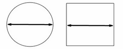
Counts the number of VrPoints (LiDAR) in a user defined area and location. Count Points may be used to calculate the number of points per square ground unit at several user selected locations. The search shape can be defined as a circle or square.

Button Assignments
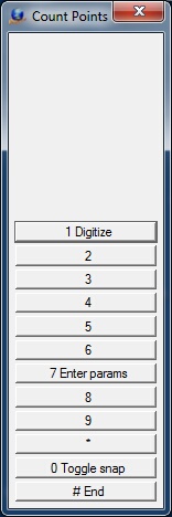
The Count Points Menu Keys
Drape Polygon – Main
|
Button |
Description |
1 |
Digitize |
Digitizes the center of the search area to find and count points. |
2 |
||
3 |
|
|
4 |
||
5 |
||
6 |
||
7 |
Parameters |
Enter parameters. |
8 |
|
|
9 |
|
|
* |
|
|
0 |
Toggle Snap |
Toggles snap on/off. |
# |
End |
Ends application. |
Parameters
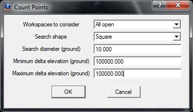
Drape To Points parameter dialog
Workspaces to consider - Defines the workspaces to consider when identifying points for change. This may be set to "Current only", or "All Open".
Search shape - When searching and counting points in a user defined area, the shape of the search area may be a Circle or Square
Search diameter (ground) - Defines the size of the search area in ground units. If a circle is chosen as the search shape, this value represents the diameter of the circle. If a square is chosen, this value represents the length of the each side. The Search
Minimum delta elevation (ground) - Defines in ground units the delta elevation below the digitized search point above which to search for points.
Maximum delta elevation (ground) - Defines in ground units the delta elevation above the digitized search point below which to search for points.