Vr Mapping |
ON-LINE REFERENCE DOCUMENTATION CARDINAL SYSTEMS, LLC |
Gap Lines (GapLin)
Type: Batch Application
Looks for touching lines and creates gaps between them.
Detailed Description
Some Digital Terrain Modeling (DTM) engines require that break lines cannot cross, touch, or be located at a node point. Gap Lines searches line end points that fall within a user specified distance to other lines and creates a gap by hacking the end or ends of the line.
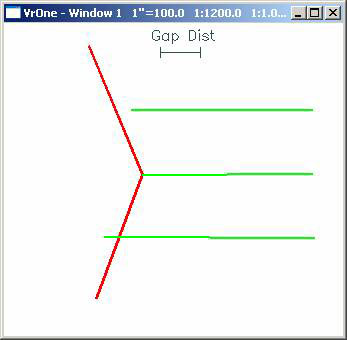
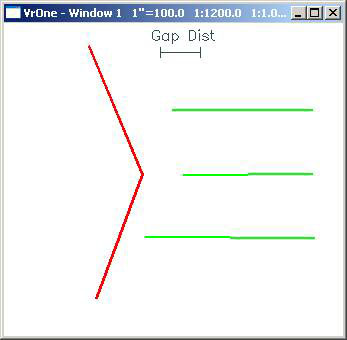
In the above example the red and green lines represent break lines. All three green lines whose end point was within the distance defined by the Gap Distance of the red line were shortened. Each line was shortened by the same amount. Even though the top green line did not touch the red line, its endpoint was within the Gap Distance of the red line.
Available Key-ins
Key-in |
Description |
Range |
PARFIL= |
Load parameter file |
Gap Lines parameter file name (.gap) |
WSTC= |
Workspaces to consider |
0=Current 1=All open |
SEALAY= |
Layers to search |
1-10001 – May be a number line |
GAPDIS= |
Gap distance |
Ground units |
RUN |
Run Gap Lines |
|
Parameters for Gap Lines
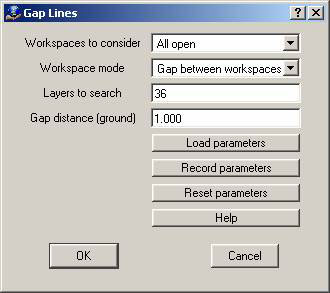
Workspaces to consider
Defines the workspaces to consider when running Gap Lines.
Workspaces mode
Can be set to “Gap Between Workspaces” or “Do Not Gap Between Workspaces”. When working on multiple workspaces, this determines whether or not line end points that meet from one workspace to another are considered for gapping.
Layers to Search
Defines the line layers to search. Lines to be gapped may be in the same layer. This parameter may be entered as a Number Line. Layers that are turned off will not be considered even if they are defined.
Gap Distance
Defines the search distance between line end points and lines they may be crossing or touching. It also defines the distance to shorten line ends that need to be gapped. The Gap Distance is entered in ground units.