Vr Mapping |
ON-LINE REFERENCE DOCUMENTATION CARDINAL SYSTEMS, LLC |
Bump Elevations (BumEle)
Type: Batch Application
Detailed Description
Searches symbol elevations against a contour interval and changes points that fall within a user-defined delta elevation from the contour interval. This batch application is useful in identifying and changing points that fall on a contour interval, especially in LiDAR data. This process avoids zero or small area contour lines that may be generated when points fall on a contour interval. For example, point elevations of 123.02 and 122.98 could be identified if the contour interval was 1 and changed. Options for changing points include applying a delta elevation shift to the points, changing their layer, and deleting them. Searching options include the definition of the contour interval, delta search elevation, and searching only for points above the contour interval.
Available Key-ins
Key-in |
Description |
Range |
PARFIL= |
Load parameter file |
Batch Node parameter file name (.bno) |
RUN |
Run Bump Elevations |
|
Parameters for Bump Elevations
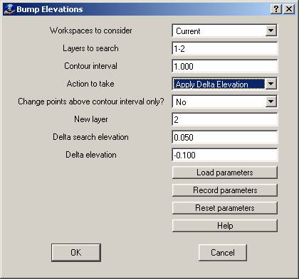
Workspaces to consider
Defines the workspaces to consider when running Bump Elevations.
Layers to search
Defines the layers to search and look for symbols whose elevations fall with the Delta search elevation.
Contour interval
Defines the contour interval to use when searching.
Action to take
When a point’s elevation falls within the Delta search elevation of a contour interval one of three actions may be taken on the point:
| • | Apply Delta Elevation – A user-defined Delta elevation will be applied to these points. First the point is rounded to the nearest contour interval then the Delta elevation is applied. |
| • | Change Layer – The points are moved to another user-defined layer. |
| • | Delete – The points are deleted. |
Change points above contour interval only?
If this parameter is set to “Yes” then only the points whose elevation falls between the contour interval and the contour interval plus the Delta search elevation will be changed. If this parameter is set to “No” then points from the contour interval minus the Delta search elevation to the contour interval plus the Delta search elevation will be changed. Since Bump Elevations is normally used to avoid the generation of contour lines from points falling on or slightly above the contour interval, the setting of this parameter to “Yes” is useful.
For example, if the contour interval is 1.0 and the Delta search elevation is 0.05 and this parameter is set to “Yes” then an elevation of 122.98 would not be changed while an elevation of 123.02 would. Using the same parameters with this parameter set to “No” would change both elevations.
New layer
If the Action to take is set to “Change Layer”, this parameter is the new layer to place points into that fall within the Delta elevation.
Delta search elevation
This defines the delta elevation from the contour interval when searching for points. This range is affected by the Change points above contour interval only parameter.
Delta elevation
If the Action to take parameter is set to “Apply Delta Elevation”, this value will be applied to the elevations of the points that fall with the contour interval range. It can be used to shift the elevation of points that fall on or slightly above a contour interval to below the contour interval to ensure that zero area or small area contours are not generated by the DTM process.
Warning:
Even though Bump Elevations is undoable, VrOne files should be backed up before use.