Vr Mapping |
ON-LINE REFERENCE DOCUMENTATION CARDINAL SYSTEMS, LLC |
Polygon Elevation (PolEle)
Type: Batch application
Changes elevation of symbols and (or) VrPoints (LiDAR) inside a polygon or group of polygons. This operation may be performed on the points or symbols in a single polygon by identifying the baseline polygon or a group baseline polygons in an interactive batch mode.
Detailed Description
This interactive batch application can be used to change the elevations of all symbols and (or) VrPoints (LiDAR) that fall within a baseline polygon to a single elevation. A baseline polygon is selected, and all points that fall within the polygon and meet the search criteria are changed to the new elevation.
This application can be applied to multiple workspaces, multiple layers, and multiple symbol graphics pointers.
Layers that are turned off will not be considered.
Available Key-ins
Key-in |
Description |
Range |
WsTc= |
Workspaces to consider |
0 - Current 1 - All |
ProSym= |
Process symbols |
0 - No 1 - Yes |
ProPoi= |
Process points |
0 - No 1 - Yes |
EleMod |
Elevation mode |
0 - Use New Elevation 1 - Use mean elevation from base line 2 - Use lowest elevation from base line 3 - Use highest elevation from base line |
NewEle |
New elevation to use if Elevation Mode is set to 0. |
Real number |
SeaGp |
Graphic pointer to search when searching for symbols. |
Number line |
SeaBas= |
Layers of base lines when processing in batch mode |
Number line |
Button Assignments
The following menu keys dialog is displayed at startup.
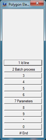
Polygon Elevation – Main
|
Button |
Description |
1 |
Id Line |
Allows selection of polygon. Displays confirm menu keys dialog. |
2 |
Batch Process |
Runs Polygon Elevation in batch mode. |
3 |
|
|
4 |
|
|
5 |
|
|
6 |
|
|
7 |
Enter params |
Enter parameters from dialog box. |
8 |
|
|
9 |
|
|
* |
|
|
0 |
|
|
# |
End |
Ends application. |
The following menu keys dialog is displayed after a polygon is selected.
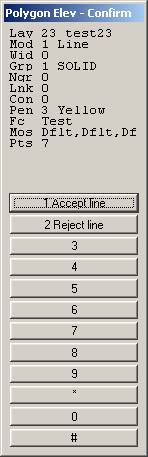
Polygon Elev – Confirm
|
Button |
Description |
1 |
Accept |
Accepts line and starts the elevation change process. |
2 |
Reject |
Rejects the line and displays the main menu keys dialog. |
3 |
|
|
4 |
|
|
5 |
|
|
6 |
|
|
7 |
|
|
8 |
|
|
9 |
|
|
* |
|
|
0 |
|
|
# |
|
|
Parameters for Polygon Elevation
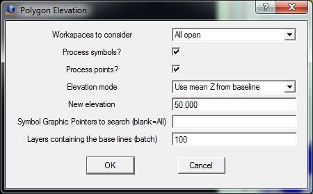
Workspaces to consider
Defines the workspaces to consider. Options are Current only or All open workspaces.
Process symbols?
Specifies whether symbols should be processed.
Process points
Specifies whether points should be processed.
Elevation mode
Specifies the mode to determine the elevation to which to set the symbols and/or points which fall within the baseline polygon or polygons. Options are:
| • | Use New Elevation - Uses the elevation defined in the New Elevation field. |
| • | Use mean Z from baseline - Uses the mean of the elevations from the points which define the baseline polygon. |
| • | Use low Z from baseline - Uses the lowest elevation from the points which define the baseline polygon. |
| • | Use high Z from baseline - Uses the highest elevation from the points which define the baseline polygon. |
Symbol Graphic Pointers to search
Specifies the graphic pointers to consider when searching for symbols. This parameter may be entered as a number line.
Layers containing the base lines (batch)
Defines the layers in which to search form baseline polygons. This parameter is used only when running Polygon Elevation in batch mode. This parameter is entered as a number line.