Vr Mapping |
ON-LINE REFERENCE DOCUMENTATION CARDINAL SYSTEMS, LLC |
Slope Line (SloLin)
Type: Interactive Application / Interactive Batch Application
Interpolates (slopes) point elevations on a line based on two existing line points. There are three modes that are available:
| 1. | The line to slope is identified and the two existing line elevations are identified. |
| 2. | The line to slope is identified and that line's end points are used as the existing points |
| 3. | All lines in layer(s) specified are sloped and the line end points are used as the existing points. |
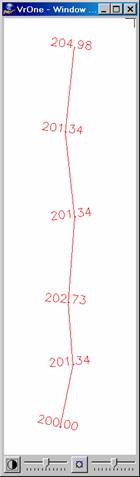
The following examples show the results of Slope Line. The example on the left shows a line before sloping and the example on the right shows the same line after sloping from the first to the last point on the line.

Local Commands
Key-in |
Description |
Range |
MOD= |
Existing points mode |
0 = Identify 1 = Use line end points |
SEALAY= |
Layers to search for lines to slope |
Number line |
WSTC= |
Workspaces to consider |
0=Current 1=All |
Button Assignments
Slope Line – Lock on
Button |
Description |
1 Id line |
Identifies a line to slope. |
2 Slope layer |
Starts batch mode to slope lines in layer(s) specified (see below). |
3 |
|
4 |
|
5 |
|
6 |
|
7 Params |
Allows entry/edit of parameters. |
8 |
|
9 |
|
* |
|
0 |
|
# End |
Ends Slope Line. |
Slope Line – Pt1/2
If the Slope Mode is set such that the user identifies the start and end point, the following menu will be displayed.
Button |
Description |
1 Dig point 1/2 |
Digitizes the start or end points |
2 Abandon |
Abandons and returns to the previous menu |
3 |
|
4 |
|
5 |
|
6 |
|
7 |
|
8 |
|
9 |
|
* |
|
0 Toggle Snap |
Turns snap on/off |
# End |
Ends Slope Lines |
Slope Line – Confirm
Button |
Description |
1 Accept |
Accepts the current slope results and re-saves the line. |
2 Reject |
Rejects the current line. |
3 |
|
4 |
|
5 |
|
6 |
|
7 |
|
8 |
|
9 |
|
* |
|
0 |
|
# End |
Ends Slope Lines. |
Slope Line – Slope Layer(s)
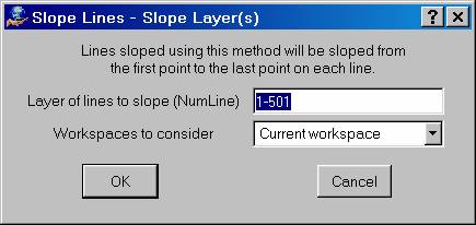
Slope Line may be run in a batch mode, in which it will slope the lines in the layers that are specified. The first and last points on the lines will be used as the base points. Multiple layers may be specified using a number line and the current or all open workspaces may be searched.