Vr Mapping |
ON-LINE REFERENCE DOCUMENTATION CARDINAL SYSTEMS, LLC |
VrVolumes
VrVolumes provides fast and flexible volume calculations between surfaces with the ease and power of VrOne. Using a Digital Terrain Model (DTM) based computation method, VrVolumes computes volumes directly from the surface triangles, yielding highly accurate results. It computes cut and fill quantities between a single ground surface and a flat elevation surface or between two ground surfaces.
An arbitrary boundary line may be selected to limit the volume calculations to a predefined area. This ensures that the volume calculations are limited to the specific area of interest. To allow maximum flexibility, the boundary line does not need to be part of the existing surfaces.
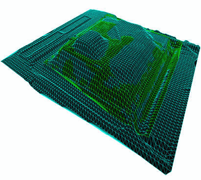
The user can save the combined surface triangles and view them for detailed analysis. This feature, in conjunction with VrOne's built-in 3D vector viewing tool, provides a quick and powerful method for analyzing volumetric data.
As part of the new volumes support, VrOne also has the ability to manage multiple surfaces at one time. Several surfaces may be loaded into memory at once, allowing the user to instantly switch between them.
Features include:
| • | Surface to flat elevation volumes computation; |
| • | Surface to surface volumes computation; |
| • | Flexible reporting with user customizable output formats; |
| • | High accuracy using direct T.I.N. based computation method; |
| • | Volume boundary limits specified using any VrOne line; |
| • | Advanced surface analysis using the 3D viewer in VrOne and VrTwo; |
| • | Runs inside VrOne for seamless job integration. |