Vr Mapping |
ON-LINE REFERENCE DOCUMENTATION CARDINAL SYSTEMS, LLC |
Correlate Area (CorAre)
Type: VrTwo Batch Application
Automatically creates a grid of points inside an existing line using automatic image correlation.
Detailed Description
Automatically places grid points at ground locations inside an existing line. Points may be placed at any grid interval. The elevations of the points are determined using automatic image correlation techniques. The correlation algorithm may be fine-tuned using several control parameters. Points may be placed on up to four different levels to quickly identify problem areas. The correlation works by selecting a point in the left stereo image and finding the matching point in the right stereo image. Based on the separation of the two points, a ground elevation is computed. NOTE: VrTwo must be running with a valid model open before using this application.
Local Commands
None
The following parameters (button 7) are used when correlating.
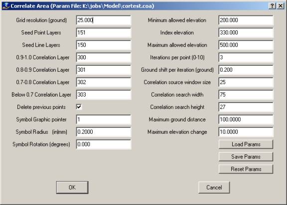
Grid resolution (ground)
Defines the spacing in ground units between grid points.
Seed Point Layers
Defines the layers in which seed points are located. Seed points are existing symbols that have already been placed at ground elevations. The seed points are used to help guide the correlation routine to prevent points from being located off the ground.
Seed Line Layers
Defines the layers in which seed lines are located. Seed lines are existing lines that have already been placed at ground elevations. The seed lines are used to help guide the correlation routine to prevent points from being located off the ground.
0.9-1.0 Correlation Layer
Defines the layer in which points are placed if 0.9≤ correlation factor ≤1.0. A layer value of 0 indicates that these points should not be placed.
NOTE: A correlation factor of 1.0 is a perfect match.
0.8-0.9 Correlation Layer
Defines the layer in which points will be placed if 0.8≤ correlation factor <0.9. A layer value of 0 indicates that these points should not be placed.
0.7-0.8 Correlation Layer
Defines the layer that points will be placed in if 0.7≤ correlation factor <0.8. A layer value of 0 indicates that these points should not be placed.
Below 0.7 Correlation Layer
Defines the layer that points will be placed in if correlation factor <0.7. A layer value of 0 indicates that these points should not be placed.
Delete previous points
Specifies whether any points in the above four correlation layers are deleted before the correlation process begins. Turning this setting on prevents duplicate points during multiple correlation runs.
Symbol graphic pointer
Specifies the graphic pointer used when placing points.
Symbol Radius (in|mm)
Defines the radius used when placing points.
Minimum elevation allowed
Defines the ground units value below which any elevations found are not used. If a point below this minimum is targeted, the current cursor elevation returns to the last good elevation or to the Index elevation if set.
Index elevation
Specifies the elevation to which the cursor should return if elevations are rejected because they fall outside the minimum and maximum allowed elevations. If this is 0.0, then the cursor elevation returns to the last good elevation.
Maximum elevation allowed
Defines the ground units value above which any elevations found are not used. If a point below this maximum is targeted, the current cursor elevation returns to the last good elevation or to the Index elevation if set.
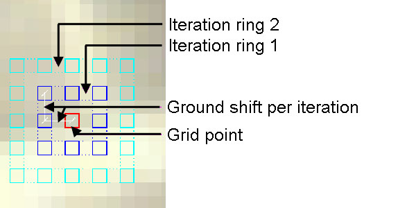
Iterations per point
Defines how many points are correlated at each grid location. A value of 0 results in only the single grid point being correlated. For each iteration, a ring of points surrounding the grid point are correlated. The point with the best correlation value is chosen for the final point placement. If a point is found with a correlation value greater than 0.9, the iteration process is stopped, and the point is chosen as the final location.
Ground shift per iteration (ground)
Defines how far each iteration ring is offset from the original grid point. This number should be at least as large as the pixel size in the stereo images.
The following illustration represents a single grid point with iterations set to 2. In this case a total of 35 points will be correlated at each grid location to determine the best correlation fit.
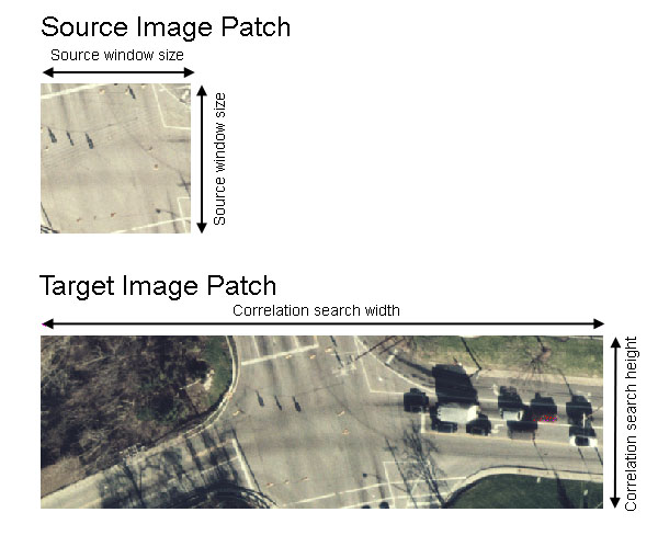
Correlation source window size
Defines in pixels the window size of the correlation source image patch. Will be matched to target image patch.
Correlation search width
Defines in pixels the width of the correlation target image patch. Determines width of area to search at each grid point.
Correlation search height
Defines in pixels the height of the correlation target image patch. Determines height of the area to search at each grid point. A value that is two pixels larger than source window height is recommended.
The following illustration represents a source image patch taken from the left image, and the target image patch taken from the right image for a single grid point. The source image patch will be compared to the target image patch until the matching pixel is found.
Maximum ground distance
Defines the maximum allowed distance in ground coordinates. If the cursor must move a distance greater than this value, correlation is rejected.
Maximum elevation change
Defines the maximum allowed elevation change in ground coordinates. When each grid point is correlated, an approximate elevation is used based on the last successfully placed point elevation, the index elevation (if the last point was invalid), or the elevation from the seed data if available. If the elevation of the final correlated point is greater than the initial elevation approximation, the correlation is rejected. When using seed points and lines, this value should be made smaller to keep the correlated points close to the seed surface.
Button Assignments
Allows searching for a line to edit.
|
Button |
Description |
1 |
Id line |
Identifies line to correlate. Displays Accept Menu. |
2 |
|
|
3 |
|
|
4 |
|
|
5 |
|
|
6 |
|
|
7 |
Enter params |
Allow entry of correlation parameters. Displays Parameters dialog. |
8 |
|
|
9 |
|
|
* |
|
|
0 |
|
|
# |
End |
Ends application. |
Allows user to accept or reject selected line.
|
Button |
Description |
1 |
Accept line |
Accepts line, begins correlation, and displays Stop menu. |
2 |
Reject line |
Rejects line and displays Lock on menu. |
3 |
|
|
4 |
|
|
5 |
|
|
6 |
|
|
7 |
|
|
8 |
|
|
9 |
|
|
* |
|
|
0 |
|
|
# |
|
|
Allows searching for a line to edit.
|
Button |
Description |
1 |
|
|
2 |
Stop |
Stops current correlation and displays Lock on menu. |
3 |
Pause |
Pauses current correlation and displays Resume menu. |
4 |
|
|
5 |
|
|
6 |
|
|
7 |
|
|
8 |
|
|
9 |
|
|
* |
|
|
0 |
|
|
# |
|
|
|
Button |
Description |
1 |
Resume |
Resumes previously paused correlation and displays Stop menu. |
2 |
|
|
3 |
|
|
4 |
|
|
5 |
|
|
6 |
|
|
7 |
|
|
8 |
|
|
9 |
|
|
* |
|
|
0 |
|
|
# |
End |
Ends correlation and display Lock on menu. |