|
What's New in Version 5

Vr Mapping version 5 contains a number of new features and enhancements to version 4. There are over 50 enhancements, additions, and bug fixes in Vr Mapping version 5. This document will give an overview of the major changes, but viewing the Release Notes is recommended for a more detailed list of the changes since version 4.
General Program Enhancements
| • | Windows 7 Support - Vr Mapping is now offered in both 64-bit and 32-bit versions. The 64-bit version of Vr Mapping version 5 is available for Windows 7 64-bit machines. This allows Vr Mapping to take full advantage of available system memory, and is especially useful for applications like VrOrtho when working with large images. The 32-bit version of Vr Mapping runs on Windows 7 64-bit and 32-bit and on Windows XP. |
| • | VrThree (VrLiDAR) - Introduction of the beta version of VrThree (VrLiDAR) which includes a new points data structure in the VrOne/VrTwo data base, LAS import and export translators, support for LiDARgrammetry, improved roaming speed in VrTwo and the addition of 3D VrThree. See VrThree (VrLiDAR) below for more details. |
| • | Improved Help System - The help system has been completely revamped in Version 5. All help is presented in one consolidated web based help system. It is now possible to quickly search through all documentation using keywords and printing of all or parts of the help is supported. Various tutorials have been added to the help system. |
| • | Apple iPad Support - Version 5 supports the Apple iPad as a touchscreen device using the Cardinal Systems' VrController app (yes, there's an app for that!). This implementation of an interactive touchscreen as an input device for VrOne and VrTwo is the the best one yet. This application can be downloaded to an iPad from Apple's App Store for free. See VrController for the iPad for more information about this magical and revolutionary input device. |
| • | VrOne/VrTwo Graphics - New graphics system for VrOne and VrTwo static mode. The overall graphics speed has been improved, and overlay graphics now uses solid cursors and rubber band lines for an overall better user experience. This change may require a newer graphics card on some systems. See Before Installing Vr Mapping Version 5 at the bottom of this document. |
| • | 3D LCD Stereo Support - Vr Mapping continues to support the NVIDIA 3D Vision Bundle which includes support the 120Hz LCD Monitors. This support continues in Windows XP and has been extended into Windows 7. |
| • | Smoother Lines and Pixels - Added support for smooth, anti-aliased line display in VrTwo roaming mode and the ability to smooth the display of pixels when zoomed in at 1:1 and closer using nearest neighbor or bilinear filters. |
| • | Plotting to system printers and PDF files - Added support for plotting directly to any Windows installed printer or directly to PDF files. When plotting using one of these new options, a preview window is displayed showing exactly what will be plotted and how it fits on the output page. |
VrThree (VrLiDAR)
Vr Mapping version 5 with the beta version of VrThree (VrLiDAR) contains a variety of enhancements to provide support for working with LiDAR data. In addition to collecting and editing vector data, LiDAR point data can be edited using VrThree (VrLiDAR). Upcoming tools such as polygon and cursor draping, bulldozing and Delete Close (DelClo) help the user to manage and refine point data. Now included in the VrOne/VrTwo graphics data base is the capability to store large amounts of LiDAR point data. This point data includes the attributes as defined in the ASPRS LAS data format. Translation to and from LAS files is a fast, simple and easy process. Other point data formats will also be supported by VrThree (VrLiDAR).
Choices for collection and editing include several environments in VrOne and VrTwo. Each environment has the ability to collect and edit vector data and edit LiDAR points. Multiple methods may be used to complete a project. All environments support user-defined point density and size display parameters. Existing VrOne/VrTwo commands and applications are available in each of the four environments.
| • | 2D ViewPoint - Very large amounts of LiDAR data can be displayed in this mode with the ability to optionally display rectified images as a backdrop. This environment is useful for cutting and management applications. |
| • | Photogrammetric Stereo - LiDAR points can be displayed with traditional photo based photogrammetry using VrTwo in static or roaming modes. Any of the Vr supported camera and sensor types may be used. |
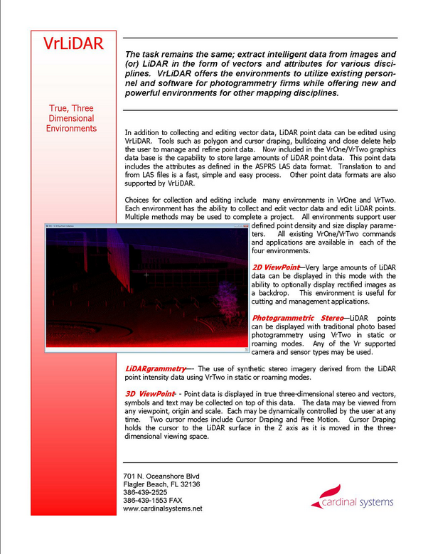
| • | LiDARgrammetry - The use of synthetic stereo imagery derived from the LiDAR point intensity data using VrTwo in static or roaming modes. |
| • | 3D VrThree - Point data is displayed in true three-dimensional stereo and vectors, symbols and text may be collected on top of this data. The data may be viewed from any viewpoint, origin and scale. Each may be dynamically controlled by the user at any time. Two cursor modes include Cursor Draping and Free Motion. Cursor Draping holds the cursor to the LiDAR surface in the Z axis as it is moved in the three-dimensional viewing space. The stereo in 3D VrThree is based on LiDAR points and VrOne vectors and does not need images. |
VrThree (VrLiDAR) Features Include:
| • | A familiar, existing Vr Mapping interface |
| • | Multiple, true three-dimensional working environments |
| • | Ability to store large amount of points along with vector data |
| • | LiDAR point and polygon editing tools |
| • | Ability to collect and edit vector mapping data on top of LiDAR data |
| • | Compatible with aerial and ground based mobile and static LiDAR data |
| • | Support for over 200 existing Vr Mapping commands and applications |
| • | Automatic Cursor Draping available in the 3D VrThree environment |
| • | Up to 16 LiDAR attributes per point including intensity and classification |
| • | User-defined point density, point size and decimation density |
| • | High speed input and output to and from LAS and other data formats |
| • | Offered as an optional option to VrOne and VrTwo |
See Getting Started with 3D VrThree for more information on 3D VrThree. Also see the VrThree (VrLiDAR) Product Brief at the bottom of this document.
NOTE: As of July 2010, VrThree (VrLiDAR) version 05.01.00 is being used in production environments and is currently in beta release. Not all the existing VrOne applications support points and polygon draping, cursor draping and bulldozing are still under development.
Mapping Enhancements
| • | Insert Line - Added option to allow line to be closed with only two current points. |
| • | Drape - Added the ability to add wall polygons in which the sides of the draped object (normally buildings) are placed as polygons instead of wall lines from the corners. |
| • | Line Cross - Added options to check for overlapping lines and three point lines that are closed. |
| • | Open Last Mode - Added user configurable option for opening last VrTwo model at startup. |
| • | Photo Name Format - Extended the method of defining the location of the strip and photo numbers within a file name. |
| • | Corner Orientations - Added corner orientation option to Image Utility. |
New Mapping Commands
| • | List Images (LisIma) - Display detailed information about all open images. Information includes pixel dimensions, depth, origin, and more. |
| • | 3D VrThree Collection (3DSC or Vr3 or VrThree) - This is a stereo viewer and collection window for LiDAR points. It is capable of real-time display and editing from large scale LiDAR datasets. |
| • | LAS Import and Export (LasIn, LasOut) - Added support for translating LiDAR points to and from VrOne/VrTwo using the LAS format. |
| • | Line Smooth (LinSmo) - Toggle line smoothing in VrTwo roaming. |
| • | Zoom Filter (ZooFil) - Smooths the display of pixels in VrTwo roaming which results in better image quality when zoomed below 1:1. |
| • | List Undo (LisUnd) - Display detailed information about the current Undo state. |
Image Enhancements
| • | Better handling of 12-bit images. |
VrThree (VrLiDAR) Product Brief
Before Installing Vr Mapping Version 5
Vr Mapping version 5 requires an OpenGL based graphics card that supports Frame Buffer Objects.
Your system can be tested for compatibility with Vr Mapping version 5 by downloading and installing a test program. This program is available on the Version 5 download page. The use of this small test program is recommended before downloading the full installation.
NOTE: Users with a Quadro FX 1400 graphics card should look over the Graphics Drivers help page and make sure they are running a supported driver version.
|