Vr Mapping |
ON-LINE REFERENCE DOCUMENTATION CARDINAL SYSTEMS, LLC |
Drape Polygon (DraPol)
Type: Interactive/Batch Application
Detailed Description
Creates a Digital Terrain Model (DTM surface) based on a user identified or user digitized polygon and optional three-dimensional symbols. VrPoints (LiDAR) or Symbols may be draped to this surface, or the surface, along with an elevation tolerance, may be used to re-classify VrPoints above, below, inside, or outside a region in reference to the surface (see "Change Data in Region Examples"). An additional option includes the deletion of VrPoints or Symbols that fall within the a region in reference to the DTM surface. The polygon is referred to as the boundary polygon.
The use of Drape Polygon for re-classification of VrPoints should be considered an editing or refinement tool to fix classification errors from previous batch applications. It should not be considered a primary tool for the initial classification of VrPoints (LiDAR). Drape Polygon considers VrPoints (LiDAR) and Symbols only.
NOTE: Drape Polygon considers the Vr Point Display (PoiDis) parameters when processing VrPoints. If a VrPoint is not displayed, it will not be considered, even if it is specified.
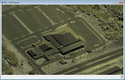
Original VrPoint (LiDAR) point data before re-classification
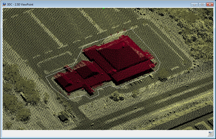
VrPoint (LiDAR) point data after re-classification
The examples above show VrPoint (LiDAR) point data with classifications on a building that are incorrect. The next example shows the result of Drape Polygon using the Drape Action of Classify to re-classify VrPoints that are within a user defined region in reference to the DTM surface Please see "Change Data in Region Examples.
Button Assignments
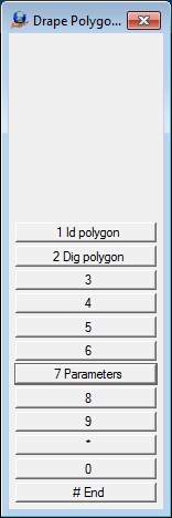
The Drape Polygon Menu Keys
Drape Polygon – Main
|
Button |
Description |
1 |
Id polygon |
Identifies an existing polygon as the boundary. |
2 |
Dig polygon |
Allows the boundary polygon to be digitized. The Insert Line application is used to digitize the line. The resulting line is not saved after processing. |
3 |
|
|
4 |
|
|
5 |
|
|
6 |
|
|
7 |
Parameters |
Allows the definition of Drape Polygon parameters (see below). |
8 |
|
|
9 |
|
|
* |
|
|
0 |
|
|
# |
End |
Ends application. |
Parameters
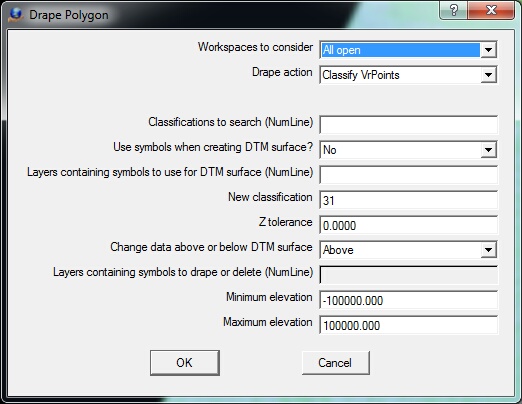
The Drape Polygon parameter dialog
Workspaces to consider - Defines the workspaces to consider when identifying points for change. This may be set to "Current only", or "All Open".
Drape action - Three options are available when considering VrPoints against the DTM surface created by the polygon and optional symbols:
| • | Drape VrPoints - VrPoints that fall within the boundary polygon are draped to the DTM surface; |
| • | Classify VrPoints - VrPoints that fall within the boundary polygon and whose elevations are within a user defined region (see "Change Data in Region Examples") will have their classification set to the "New classification"; |
| • | Delete VrPoints - VrPoints that fall within the boundary polygon and whose elevations are above or below the DTM surface plus the "Z tolerance" will be deleted. |
| • | Delete VrPoints All Elevations - VrPoints that fall within the boundary polygon will be deleted without consideration of their elevations. |
| • | Drape Symbols - Symbols that fall within the boundary polygon are draped to the DTM surface. |
| • | Delete Symbols - Symbols that fall within the boundary polygon and whose elevations are within a user defined region (see "Change Data in Region Examples") will be deleted. |
Classifications to search (NumLine) - Defines the classifications to search for when processing VrPoints. Normally points that are displayed are considered but using this parameter allows all points to be displayed while only the classifications defined will be considered for modification. Leaving the field blank will indicate that all VrPoints that are displayed will be considered. A Number Line may be used to define this parameter.
Use symbols when creating the DTM surface? - When active, symbols that are in the "Layers containing symbols" and are within the boundary polygon will be used along with the points on the polygon to define the DTM surface.
Layers containing symbols to use for DTM surface (NumLine) - If the "Use symbols when creating DTM surface" is set to Yes then this parameter will be used to define the layers containing symbols to be used to supplement the DTM surface. A Number Line may be used to define more than one layer.
New classification - If the "Drape action" is set to "Classify VrPoints" then the VrPoints that meet the search criteria are changed to the Classification number defined by this parameter.
Z tolerance - If the "Drape action" is set to "Classify VrPoints" or "Delete VrPoints" or "Delete Symbols" then this parameter defines the minimum vertical distance above or below the DTM surface. This distance will be combined with a user defined region to determine what data will be re-classified or deleted (see "Change Data in Region Examples").
Change data in region - If the "Drape action" is set to "Classify VrPoints" or "Delete VrPoints" or "Delete Symbols" then this parameter defines the region of the DTM surface to modify data. Options are Above, Below, Inside, or Outside
In the following parameter definition, DTM is the DTM surface and ZToler is the Z Tolerance parameter (see "Change Data in Region Examples").
| • | Above - The region above DTM+ZToler |
| • | Below - The region below DTM-ZToler |
| • | Inside - The region between DTM-ZToler and DTM+ZToler |
| • | Outside - The regions above DTM+ZToler and below DTM-ZToler |
Layers containing symbols to drape or delete - If the "Drape actions" is set to "Drape Symbols" or "Delete Symbols", this parameter is used to define the layers containing symbols that are draped or deleted if they fall within the boundary. A Number Line may be used to define more than one layer.
Minimum elevation - Defines the minimum elevation for VrPoints or Symbols to be considered.
Maximum elevation - Defines the maximum elevation for VrPoints or Symbols to be considered.
Change Data in Region Examples
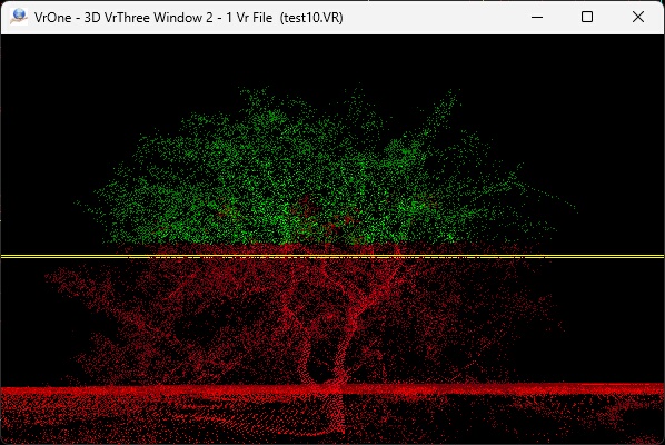
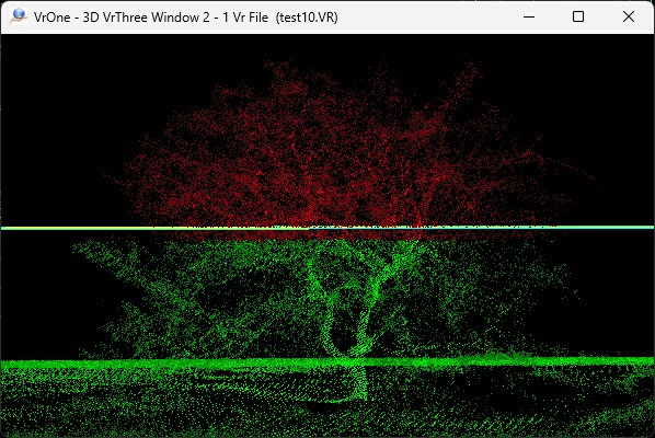
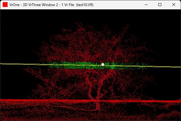
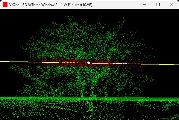
The following examples show the result of each of the "Change data in region" parameters. This example is not intended to be a real-world example but an illustration of the effect of each of the possible parameters. Shown is a cross section view of a tree with the DTM surface shown as the yellow horizontal line which is a flat surface in this example. The points in red are points with their original classification and the points in green are the draping result.
Above
Above
The region above the DTM surface plus the Z Tolerance. The Z Tolerance is 1.0 in this example.
Below
Below
The region below the DTM surface minus the Z Tolerance. The Z Tolerance is 1.0 in this example.
Inside
Inside
The region between the DTM surface minus the Z Tolerance and the DTM surface plus the Z Tolerance. The Z Tolerance is 1.0 in this example.
Outside
Outside
The region above the DTM surface plus the Z Tolerance and below the DTM surface minus the Z Tolerance. The Z Tolerance is 1.0 in this example.
Local Commands
Key-in |
Description |
Range |
WsTc= |
Workspaces to consider |
0=Current 1=All open |
DraAct= |
Drape Action |
0=Drape VrPoints 1=Classify VrPoints 2=Delete VrPoints 3=Delete VrPoints All Elevations 4=Drape Symbols 5=Delete Symbols |
SeaCla= |
Classifications to search |
Number Line |
UseSym= |
Use symbols for DTM surface |
0=No 1=Yes |
DtmSymLay= |
Symbol layer(s) to use for DTM surface |
Number Line |
NewCla= |
New Classification number |
0-31 |
ZTol= |
Z tolerance |
Ground units |
ChgReg= |
Change data in Region |
0=Above 1=Below 2=Inside 3=Outside |
DraSymLay= |
Symbol layer(s) to drape or delete |
Number Line |
MinZ= |
Minimum elevation for VrPoints or Symbols to be considered |
Ground units |
MaxZ= |
Maximum elevation for VrPoints or Symbols to be considered |
Ground units |
Modified "Change data above or below DTM Surface" to "Change data in region" version 07.01.23 - July 2024