Vr Mapping |
ON-LINE REFERENCE DOCUMENTATION CARDINAL SYSTEMS, LLC |
KML Out (KmlOut)
Type: Translator
Translates VrOne lines and symbols into a KML (Keyhole Markup Language) file that can be displayed in an Earth browser such as Google Earth.
KML uses a tag-based structure with nested elements and attributes and is based on the XML standard. KML is an international standard maintained by the Open Geospatial Consortium, Inc. (OGC).
The coordinate system for Earth browsers such as Google Earth is WGS (World Geodetic System) 84. This coordinate projection uses longitude and latitude which are in angular units (i.e. -81.057995, 29.196447) that are expressed in decimal degrees. The z (elevation or altitude) coordinate, if used, is expressed in meters (i.e. 10.2654). The EPSG code for WGS 84 is 4326.
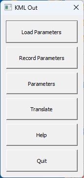
The KML Out button box.
Loads previously recorded KML Out (.kmo) parameter file.
Records current translation parameters to a KML Out (.kmo) parameter file.
Allows editing of the translation parameters.
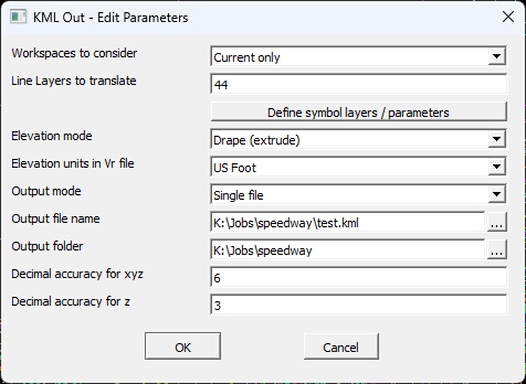
The Edit Parameters dialog box
Workspaces to consider
Defines the workspaces to consider when exporting KML Out files. Options are "Current only" and "All open".
Line Layers to translate
Defines the line layers in the VrOne file(s) to translate. These lines will be translated to the KML file using the approximate color and line weight defined in the VrOne file. A Number Line may be used to define these layers.
Define symbol layers / parameters
This button will display the Edit Symbol Parameters dialog box (see below).
Elevation mode
Defines the mode to use for line point and symbol elevations.
| • | Drape (extrude) - Drapes the elevations onto the Earth browser's surface. It should be noted that this draping will be influenced by features such as vegetation. |
| • | Use Vr entity elevation - The elevation of each line point and symbol will be used. |
Elevation units in Vr file
If the Elevation mode is set to "Use Vr entity elevation" then this parameter will be used to convert from US Survey Foot or International Survey Foot to meters. The Earth browser's elevation units is defined in meters. The options are "US Foot", "International Foot", or "Meters".
Output mode
Determines handling of output files during translation.
| • | Single File - All open workspaces are translated into a single Survey Points file. The "Output file name" field determines the output file name. The "Output directory" field may be used to place the output file in a different folder than the VrOne file. |
| • | One File Per Workspace - A Survey Points file is created for each open workspace. The output filename is the same as the workspace (VrOne) filename with a .kml extension. The "Output directory" field may be used to place the output files in a different folder than the VrOne files. |
Output file name
Defines the output file name when "Output mode" is set to "Single File". This name is ignored if "Output mode" is set to "One file per workspace". The file extension for a KML file is .kml
Output folder
Defines the folder name to place the output file(s). This field may be left blank to place the output files in same the directory as the VrOne files.
Decimal accuracy for xy
Defines the number of decimal places for the x, y geographic coordinates in the output file(s). The coordinate system for Earth browsers such as Google Earth is WGS (World Geodetic System) 84. This coordinate projection uses longitude and latitude which are in angular units (i.e. -81.057995, 29.196447) that are expressed in decimal degrees.
Decimal accuracy for z
Defines the number of decimal places for the z (elevation or altitude) in the output file(s). The z coordinate is expressed in meters (i.e. 10.2654).
Begins the file translation process. Upon completion, KML (.kml) file or files will be created. Double clicking on a .kml file in the Windows File Explorer will typically start Google Earth and drive to the location defined in the KML file.
Starts the browser and displays the current help document.
Quits KML Out and allows current parameters to be saved if they were altered.
When Vr lines are displayed in the Earth browser (Google Earth), the color and weight from Vr are used (Line fonts such as tree lines are not supported). When symbols are displayed there is a single default marker or icon that is used. The Edit Symbol Parameters allow symbols to be grouped by layer with different display parameters. These parameters include an icon definition and scale factor and options for the icon label text. Up to 10 symbol definitions, or passes, are available.
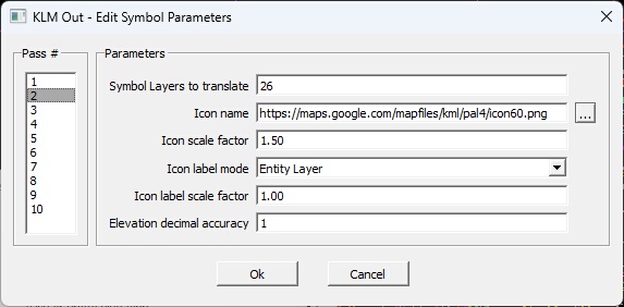
The Edit Symbol Parameters dialog box
Symbol Layers to translate
Defines the symbol layers in the VrOne file(s) to translate for the current pass. A Number Line may be used to define these layers.
Icon name
An icon is used to mark the location of the symbol. This icon (or placemark) is defined using a Portable Network Graphic (.png) file. This file may be located on your local computer or an Internet site such as http://kml4earth.appspot.com/icons.html or Google "icons for google earth" for more icons. If the icon name is not defined or or the defined icon cannot be found, the default icon will be used. The default icon for Google Earth is the yellow pushpin.
Icon scale factor
Scales the icon. A scale factor of 1 displays the icon with no scaling.
Icon label mode
Defines the text label to be used for the icon (symbol).
| • | No label - The icon will not be labeled. |
| • | Entity elevation - The Vr symbol entity elevation will be used as the label. This label will be in the same units (i.e. US Survey Foot) as the Vr file. The decimal accuracy may be specified with the "Elevation decimal accuracy" parameter. |
| • | Entity Layer - The layer number of the Vr symbol entity will be used as the label. |
| • | Entity Feature Code - The Feature Code of the Vr symbol entity will be used as the label if it is defined. |
Icon label scale factor
Scales the icon label. A scale factor of 1 displays the icon label with the default size.
Elevation decimal accuracy
If the "Icon label mode" is set to "Entity elevation", this parameter will define the number of digits to the right of the decimal point that will be displayed.
The following are required to use KML Out
| • | Google Earth or compatible Earth browser must be installed. |
| • | The VrOne file projection must be defined. Since the coordinate system used by Google Earth is WGS 84 and State Plane coordinate systems are common in Vr Mapping, the conversion from State Plane to WGS 84 must be performed by KML Out. The coordinate system for Earth browsers such as Google Earth is WGS (World Geodetic System) 84. This coordinate projection uses longitude and latitude which are in angular units (i.e. -81.057995, 29.196447) that are expressed in decimal degrees. The coordinate projection for a VrOne file can be set in File -> Edit Vr Header -> Coordinate projection. If using a state plane coordinate system, the easiest method to define a projection is to use an EPSG code. The Search button will display a list of supported EPSG projections. |
KML Out (KMLOut) added July 2023 - Version 07.01.21