Vr Mapping |
ON-LINE REFERENCE DOCUMENTATION CARDINAL SYSTEMS, LLC |
LAS Out (LasOut)
Type: Translator
Translates Vr Points to the LAS (LiDAR Archive Standard) format.
The LAS file format is a public file format for interchanging LiDAR data between computer systems. This binary file format consists of point coordinate data along with up to 16 attributes per point. The LAS In and LAS Out translators maintain these attributes in the Vr Mapping database. The translation of LAS data to and from the Vr Mapping database requires very few parameters. The LAS translators are based on the LAS Specification Version 1.2 and the LAS Specification Version 1.4. The support of version 1.4 was added in Vr Mapping version 05.09.00. Please see LAS Version 1.2 and LAS Version 1.4 Support for more information. Support for the output of compressed LAS (LAZ) files was added in Vr Mapping Version 06.00.06.
LiDAR points are stored as Vr Points and maintain LAS defined point attributes.
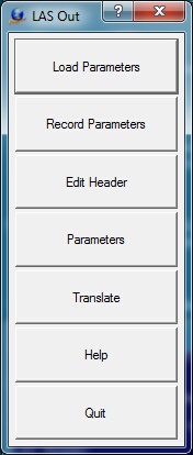
Loads previously recorded Las Out (.lao) parameter file.
Records current translation parameters to a Las Out (.lao) parameter file.
Edits the LAS file header used when creating LAS or LAZ files.
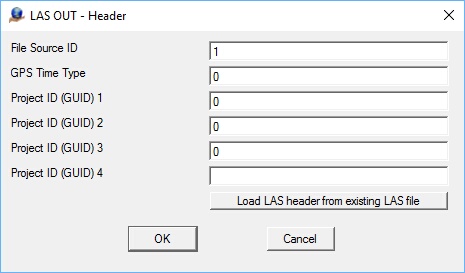
The Define LAS Header dialog box
File Source ID
This field should be set to a value between 1 and 65,535 inclusive (Flight Line Number if this file was derived from an original flight line). 0 means an ID has not been assigned. In that case, processing software is free to assign any valid number. Note that this scheme allows a LiDAR project to contain up to 65,535 unique sources. A source can be an original flight line or the result of merge and/or extract operations.
GPS Time Type
Specifies the meaning of GPS Time in the Point Records. 0 indicates that GPS time in the point record fields is GPS Week Time (the same as previous versions of LAS). 1 indicates that GPS Time is standard GPS Time (satellite GPS Time) minus 1 x 10⁹. The offset moves the time back to near zero to improve floating point resolution.
Project ID (GUID)
Project ID (GUID data): The four fields that comprise a complete Globally Unique Identifier (GUID) are now reserved for use as a Project Identifier (Project ID). The field remains optional. The time of assignment of the Project ID is at the discretion of processing software. The Project ID should be the same for all files that are associated with a unique project. By assigning a Project ID and using a File Source ID (defined above) every file within a project and every point within a file can be uniquely identified, globally.
Allows editing general translation parameters.
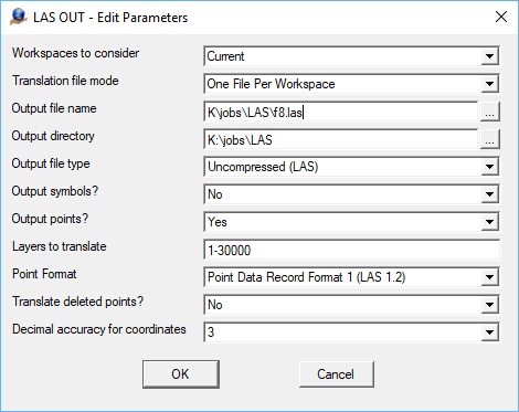
The Edit Parameters dialog box
Workspaces to consider
Defines the workspaces to consider when running exporting LAS files. Options are "Current workspace" and "All open workspaces".
Translation file mode
Determines handling of output files during translation.
| • | Single File - All open workspaces are translated into a single LAS file. The "Output file name" field determines the LAS file name. |
| • | One File Per Workspace - An LAS file is created for each open workspace. The LAS filename is the same as the workspace (VrOne) filename with an .las or .laz extension. The "Output directory" field may be used to place the LAS files in a different folder than the VrOne file. |
Output file name
Defines the output file name when "Translation file mode" is set to "Single File". This name is ignored if "Translation file mode" is set to "One file Per Workspace".
Output directory
Defines the output directory if not using "Single File" translation mode. This field may be left blank to place the output files in same the directory as the VrOne files. This field is ignored if the "Translation file mode" is set to "Single File".
Output file type
The files output from LAS Out may be uncompressed (.las) or compressed (.laz). When the "Translation file mode" is set to "One File Per Workspace", the output files will have a .las or .laz file extension depending on this parameter.
Output Symbols
Determines whether to output Symbols. The LAS Out translator typically exports Vr Points only. Symbols do not carry LiDAR attributes like Vr Points; default values are assigned to these attributes for each symbol.
Output Points
Determines whether to export Vr Points. This parameter is normally set to "Yes".
Point Format
The point data format ID corresponds to the Point Data Record format type. LAS 1.2 defines types 0, 1, 2, and 3. LAS 1.4 defines types 6, 7, and 8. Following are the attributes included in each format as defined by the LAS Specification 1.2 and LAS Specification 1.4.
| • | Format 0 (LAS 1.2) - X, Y, Z, Intensity, Return Number, Number of Returns, Scan Direction Flag, Edge of Flight Flag, Classification, Scan Angle Rank, User Data, Point Source ID |
| • | Format 1 (LAS 1.2) - X, Y, Z, Intensity, Return Number, Number of Returns, Scan Direction Flag, Edge of Flight Flag, Classification, Scan Angle Rank, User Data, Point Source ID, GPS Time |
| • | Format 2 (LAS 1.2) - X, Y, Z, Intensity, Return Number, Number of Returns, Scan Direction Flag, Edge of Flight Flag, Classification, Scan Angle Rank, User Data, Point Source ID, Red, Green, Blue |
| • | Format 3 (LAS 1.2) - X, Y, Z, Intensity, Return Number, Number of Returns, Scan Direction Flag, Edge of Flight Flag, Classification, Scan Angle Rank, User Data, Point Source ID, GPS Time, Red, Green, Blue |
| • | Format 6 (LAS 1.4) - X, Y, Z, Intensity, Return Number, Number of Returns, Scan Direction Flag, Edge of Flight Flag, Classification, Scan Angle Rank, User Data, Point Source ID, Overlap flag, Sensor number, GPS Time |
| • | Format 7 (LAS 1.4) - X, Y, Z, Intensity, Return Number, Number of Returns, Scan Direction Flag, Edge of Flight Flag, Classification, Scan Angle Rank, User Data, Point Source ID, Overlap flag, Sensor number,GPS Time, Red, Green, Blue |
| • | Format 8 (LAS 1.4) - X, Y, Z, Intensity, Return Number, Number of Returns, Scan Direction Flag, Edge of Flight Flag, Classification, Scan Angle Rank, User Data, Point Source ID, Overlap flag, Sensor number,GPS Time, Red, Green, Blue, Near Infrared Channel (NIR) |
See the Vr Point format for more information on these fields and any differences between the Vr Point format and the LAS specification.
Layers to translate
Defines the layers to translate to LAS. If a layer is specified, it is translated even if it is turned off in VrOne/VrTwo.
Translate deleted points
One of the attributes stored with each Vr Point is a delete flag, which allows points in the database to be marked as deleted. If this parameter is selected, deleted points will be translated. Translated deleted points retain their delete flag in the LAS output file.
Decimal Accuracy for coordinates
Defines the decimal accuracy for the coordinates. When point coordinates are stored in a LAS file, a scale factor and offset are applied. If the decimal accuracy is too high, it is reduced automatically.
Begins the file translation process.
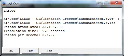
The Translation information box
Starts the browser and displays the current help document.
Quits LAS Out and allows current parameters to be saved if they were altered.
LAS Version 1.2 and LAS Version 1.4 Support
LAS 1.2 and LAS 1.4
For more information on the supported LAS formats please see:
Overview of Changes in 1.4
Following is an overview of the changes from LAS 1.2 to LAS 1.4. This list does not include all the differences. Please see the LAS format specifications for more details.
| • | The number of returns per LiDAR pulse and the return number has been extended from 5 to 15. |
| • | The sensor number is now included in version 1.4 and has a range from 0 to 3. |
| • | The overlap flag has been added. |
| • | The number of point classifications has been extended from 32 to 256. |
| • | The Near Infrared Channel (NIR) field has been added. |
| • | The scan angle is now defined with a range of -30,000 to 30,000 with a resolution of 0.006 degrees. |
Supported Point Data Records
LAS 1.4 supports waveform data, however the Vr Mapping LAS translators does not support this data so the LAS Point Data Record formats 4, 5, 9 and 10 are not supported. LAS 1.4 consists of 11 Point Data Record formats. Formats 0-3 are legacy formats from version 1.2 which are still supported and formats 6-8 are defined in the 1.4 specification. For more details on each of the supported point formats, please see the LAS format specifications in the LAS documentation listed above. Following are the record formats supported by Vr Mapping.
| • | Format 0 (LAS 1.2) - X, Y, Z, Intensity, Return Number, Number of Returns, Scan Direction Flag, Edge of Flight Flag, Classification, Scan Angle Rank, User Data, Point Source ID |
| • | Format 1 (LAS 1.2) - X, Y, Z, Intensity, Return Number, Number of Returns, Scan Direction Flag, Edge of Flight Flag, Classification, Scan Angle Rank, User Data, Point Source ID, GPS Time |
| • | Format 2 (LAS 1.2) - X, Y, Z, Intensity, Return Number, Number of Returns, Scan Direction Flag, Edge of Flight Flag, Classification, Scan Angle Rank, User Data, Point Source ID, Red, Green, Blue |
| • | Format 3 (LAS 1.2) - X, Y, Z, Intensity, Return Number, Number of Returns, Scan Direction Flag, Edge of Flight Flag, Classification, Scan Angle Rank, User Data, Point Source ID, GPS Time, Red, Green, Blue |
| • | Format 6 (LAS 1.4) - X, Y, Z, Intensity, Return Number, Number of Returns, Scan Direction Flag, Edge of Flight Flag, Classification, Scan Angle Rank, User Data, Point Source ID, Overlap flag, Sensor number, GPS Time |
| • | Format 7 (LAS 1.4) - X, Y, Z, Intensity, Return Number, Number of Returns, Scan Direction Flag, Edge of Flight Flag, Classification, Scan Angle Rank, User Data, Point Source ID, Overlap flag, Sensor number,GPS Time, Red, Green, Blue |
| • | Format 8 (LAS 1.4) - X, Y, Z, Intensity, Return Number, Number of Returns, Scan Direction Flag, Edge of Flight Flag, Classification, Scan Angle Rank, User Data, Point Source ID, Overlap flag, Sensor number,GPS Time, Red, Green, Blue, Near Infrared Channel (NIR) |
Additions and Modifications to the LAS Specification
| • | Vr Mapping contains a layer number for each point (1-32001) |
| • | Vr Mapping contains a flight number for each point (0-255) |
| • | Vr Mapping contains a display flag for each point (0-1) |
| • | The red, green, and blue values in LAS point data record formats 2, 3, 7, and 8 are defined with a range of 0-65535 (6 bytes). Vr Mapping scales these values to 0-255 (3 bytes) |
| • | LAS version 1.4 waveform data is not supported so LAS Point Data Record formats 4, 5, 9 and 10 are not supported. |
| • | LAS version 1.4 specifies the maximum number of points in an LAS file to be up to18 quintillion (18,446,744,073,709,551,615). Currently, Vr Mapping supports the LAS 1.2 specification which allows point counts up to 4 billion (4,294,967,295). |
Updated: May 2019