Vr Mapping |
ON-LINE REFERENCE DOCUMENTATION CARDINAL SYSTEMS, LLC |
VrThree (VrLiDAR)
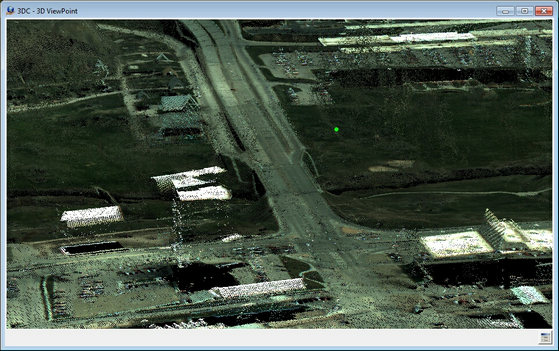
LiDAR data displayed in RGB
Overview
LiDAR (Light Detection And Ranging) is an optical sensing technology that measures the distance to a target by illuminating the target with light, often using pulses from a laser. LiDAR point collection results in georeferenced XYZ points with attribute data for each point.
VrThree (VrLiDAR) integrates LiDAR data and processing into the VrMapping's VrOne and VrTwo mapping software. In addition to LiDAR data, the applications can handle any 3D point data from other sources such as High Density Surface Models (DSM).
VrThree (VrLiDAR) consists of:
| • | Vr data base (.vr) support for LiDAR data, including LiDAR point attributes. |
| • | Import and export of LiDAR data. |
| • | Integration of LiDAR processing into existing mapping applications where applicable. |
| • | Implementation of LiDAR specific applications, such as VrThree (VrLiDAR). |
An example of the integration of LiDAR data into an existing Vr Mapping applications can be found in the Vr Mapping application Cut Polygon. Cut Polygon was designed to cut traditional map data such as lines, symbols, and text; now, it can cut LiDAR data. Similarly, LiDAR-specific applications can function with other data types. For example, VrThree, which was designed to display LiDAR and other point clouds and collect and edit vector data on top of this data, has the ability to display vector data only (no images).
Documentation for individual applications can be found in the VrOne/VrTwo List Of Commands.
Viewing Environments
2D in VrOne
Displays large quantities of LiDAR data. Optionally, rectified images can be displayed as a backdrop. Useful for cutting and management applications.
Photogrammetric Stereo
Displays LiDAR points with traditional photo-based photogrammetry using VrTwo in static or roaming mode. Any supported camera and sensor types may be used.
LiDARgrammetry
Displays synthetic stereo images (derived from LiDAR point intensity data) using VrTwo in static or roaming modes.
VrThee (VrLiDAR)
Displays point data in true three-dimensional stereo imagery with dynamic view. Vectors, symbols, and text may be collected on top of the point data. Two cursor modes are supported: Cursor Draping (cursor is held to the LiDar surface in the Z-axis) and Free Motion (cursor may move freely through the Z-axis). Static and roaming modes are supported. See Getting Started With VrThree (VrLiDAR) for more information.
LiDAR data is opened in Vr Mapping as a standard VrOne file and is displayed with corresponding vector map data in all environments.
The LiDAR Database
LiDAR point data with attributes, like lines, symbols, and text, is contained in the VrOne database (.vr) file as VrPoints. See VrOne Database Structure for more information about the database and see VrPoint (LiDAR) Entity for more information on the storage of LiDAR data in the VrOne database.
VrThree (VrLiDAR) Applications
VrThree (VrLiDAR) integrates LiDAR data into existing mapping applications and implements LiDAR-specific applications. The following is a list of Vr Mapping applications that deal with LiDAR data. More information on any of these applications can be found the VrOne/VrTwo List of Commands.
A High/Low point searching method is available when using some of the LiDAR interactive collection and batch applications. High/Low point searching is an addition to various insert applications such as Insert Line (InsLin) and Insert Symbol (InsSym). It selects the highest, lowest or mean elevation point from a group of VrPoints within a user-defined radius of the digitized point.
As of Vr Mapping version 05.05.00, work is ongoing on the integration of the VrPoint (LiDAR) portion of the data base into existing applications. Applications marked with a '+' are integrated into the VrPoints (LiDAR) database.
3DSC or Vr3 or VrThree or 3DC |
+ |
|
AscIn |
+ |
|
AscOut |
+ |
|
BumEle |
+ |
|
CatPoa |
+ |
|
Change Units |
ChaUni |
+ |
ChaEle |
+ |
|
ChaLay |
+ |
|
Cla3d |
+ |
|
ClaPoi or BarEar |
+ |
|
CopPol |
+ |
|
CopWin |
+ |
|
CouPoi |
+ |
|
CopPol |
+ |
|
CutShe |
+ |
|
CutWin |
+ |
|
DelClo |
+ |
|
Delete Duplicates |
DelDup |
+ |
DelOut |
+ |
|
DelPoi |
+ |
|
DelWin |
+ |
|
Dra |
+ |
|
Drape Cursor |
DraCur |
+ |
DraPol |
+ |
|
EdiPoi |
+ |
|
FasDel |
+ |
|
various |
+ |
|
Identify Any |
IdentAny |
|
InsCat |
+ |
|
InsEdg |
+ |
|
InsPai |
+ |
|
Inverse |
Inv |
+ |
LabPoi |
+ |
|
KeyPoi |
+ |
|
LasIn |
+ |
|
LasOut |
+ |
|
MovPol |
+ |
|
MovWin |
+ |
|
PolEle |
+ |
|
PoiDis or PO |
+ |
|
PoiIn |
+ |
|
PoiOut |
+ |
|
RouEle |
+ |
|
Search Elevation |
SeaEle |
+ |
Set Elevation |
SetEle |
+ |
Shift Workspace |
ShiWs |
+ |
SwaAxi |
|
|
TilPoi |
+ |
|
Glob |
+ |
|
Plo |
|
|
WinCli |
+ |